GF Tengchong: check updated course maps

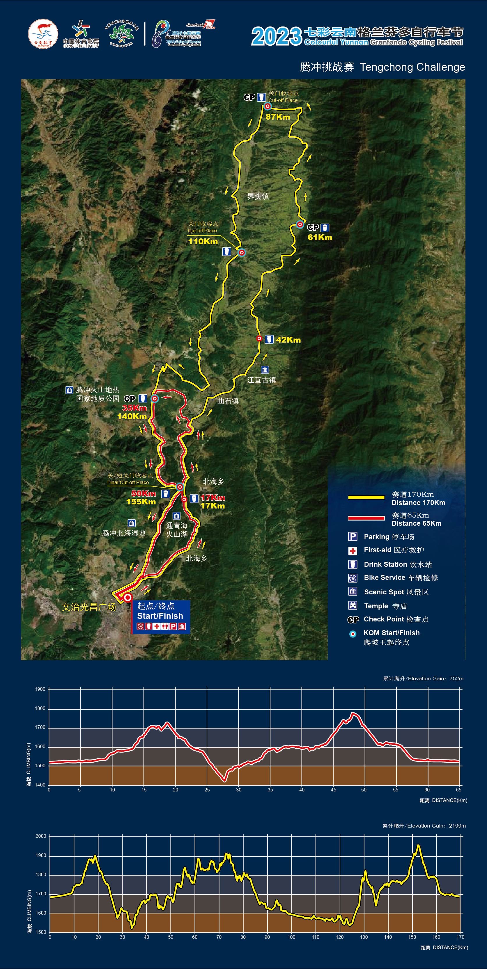
The course maps of the upcoming Granfondo Tengchong on 29 and 30 September have been updated following the technical team’s inspection last week. Stage 1, named Epic Tengchong, has been measured as 85 km for long distance participants and 52km for short distance riders. Stage 2, Along Gaoligong, is based on the previous 2018 and 2019 courses and will measure at least 170 km for long, and 65km for short distance competitors. There will be a General Classification based on each rider’s finish time in the two stages.
Both stages start and finish in the city of Tengchong at Wenzi Square. People who took part in 2018 or 2019 know that the area around here is ridiculously beautiful for cycling, but also technical to very technical in parts. Anyone signing up for - in particular - the long distance should be aware of this and come prepared. There’s hardly a place in the world where so many corners need to be taken, also in fast downhill sections. Competitively speaking, this is a race for punchers, for riders with a good amount of explosivity in the legs as well as energy management skills. In the two previous editions of the Along Gaoligong stage, riders who had started too fast blew up spectacularly in the second half.
Epic Tengchong starts with a gradual uphill section on a wide main road out of the city until a turning point at km 12. Then it goes mainly downhill towards the split for long and short distance riders. Long goes straight, short takes a left bend to go back towards the finish. The 85km will then head towards a nasty little climb that ultimately leads to Simola, a tourist attraction famous for its flower gardens. Then it’s still some significant up & down until the main road back to the finish. This stage is a great warm-up for the second day, which is the real test of strength.
The 2023 course looks more like the 2018 than the 2019 version. The first 90km are even exactly the same and include the Wall of Tian Tai at around km 62, a cobblestone climb in the spirit of the Tour of Flanders. You will be riding through small villages, flower and vegetable fields on the lower slopes of the Gaoligong mountain range on your right side. The return to the city after AS 4 is quite different from before, however. The aim is to stay away from the main road as much as possible and follow a picturesque river path. Eventually we do have to get back briefly on a main road, only to take a right turn up a new and challenging hillclimb. Reaching the summit, you better make sure you are lucid because the descent is fast and requires focus around the switchbacks. The road is wide and surface is good, however. That brings riders towards the volcanic park, where we reconnect with the ‘old course’. However, we will traverse the volcanic area differently as well. Many will already smell the finish here, but you are not quite there yet… Only when you reach the final checkpoint and aid station at km 155 you can start breathing a sigh of relief. From there it is mainly downhill to the finish back in the city. Short distance riders obviously have a much less technical course, and will enter the volcanic park from a different road. Once there, they follow the same course as the long distance participants.
The estimated elevation gain for long distance Epic Tengchong is 1400 hm , and 2800 hm for Along Gaoligong.
Please note that adjustments may still need to be made in the final days leading up to the event. This area is prone to damaged roads as a result of the wet season, which should be ending about now. It is why one of 2019’s favourite sections, the Minggan climb, cannot be used this year. There is a possibility that the Along Gaoligong stage will be extended by another 5 kilometres towards the end, which would make it 175km long instead of 170km.
The GPX files of both stages will be made available in the week leading up to the event.

Stage 1
Stage 2